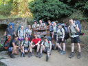
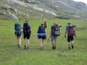
Exercise Granite EMU was a two-week mountaineering expedition run by Officer Cadets from East Midlands UOTC in July 2016. 14 members of EMUOTC trekked the northern half of the GR20 trail in Corsica - widely regarded to be one of the hardest routes in Europe. The expedition was organised and led by OCdt Zoe Ashbridge and OCdt Luke Nasipler, and our mountain leader was Maj David Larkam. EMUOTC are incredibly grateful for the financial support provided by the Ulysses Trust, as this enabled us to offer the trip to all Officer Cadets regardless of their financial situation.
18th - 19th July The expedition started early with a 6am meet at Gatwick Airport. The first flight took us to Nice, and from there we flew to Corsica. The city of Calvi has a tiny airport, which we travelled to on a similarly tiny plane! We arrived in the 35°C heat, with a beautiful backdrop of mountains surrounding the airport. They looked very steep, and we would shortly be climbing them! A day was dedicated to kit prep: group kit was divided out, cooking groups decided on, and 4 days of food supplies bought. Luckily we had a couple of hours free in the afternoon to explore Calvi. The city has a rich history - it was the birthplace of Christopher Columbus, and its ancient citadel is a base for the French Foreign Legion. We then got an early night in preparation for a hard day of trekking
.
20th July The trek begins! We woke early and got taxis to the village of Calenzana at 7:30am. The sun was already shining bright, promising a hot day. The unofficial start of the trail is Le GR20 Bar Restaurant in the centre of the village. From there, we headed up through the village until the road became a track, rapidly receding to a small path that disappeared into the woods.
The first day was relentlessly uphill - 12km, 1550m ascent, 235m descent. However the path was well-trodden and we made good progress despite the heat. Within the first hour we spotted a bright green lizard scurrying across a rock, and excitedly stopped to take photos - however we quickly learnt that seeing lizards was not a rare occurrence! We made it to Refuge dOrtu di u Piobbu at 5pm, 9 hours after we started, with tired legs and empty water bottles. It was a tough first day, but the scenery was well worth the effort!
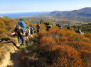
21st July Day two of the trail, and it was also Emmas birthday! We were up at dawn for a 6am start, hoping to get most of the hard work done before the midday heat. The terrain was particularly rugged and varied; we started by descending through woods to a small river, then immediately embarking on a long climb up the opposite mountainside. We reached the Bocca Piccaia shortly before 11am, and were rewarded with some of the most breath-taking views of the whole trail. However the ascent was not by any means over! The afternoon was spent picking a path carefully across scrambly terrain as we crossed the ridge, followed by a long descent to Refuge de Carozzu. Although we walked a mere 8km, this involved 750m ascent and 1050m descent and took 11 hours!
22nd July This was another hard day - but also another birthday! We were encouraged by the promise of a restaurant at the next refuge; we were looking forward to a celebratory birthday meal for Emma and Jon.
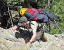
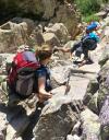
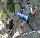
The day started with a steep descent and a wobbly suspension bridge to cross the Spasimata gorge. It took several hours to climb the Spasimata slabs - smooth rock that at times required fixed cables to ascend. We were grateful for the good weather, as rain or ice wouldve made the slabs impossible to cross. After the tough climb, we stopped for a while to swim in the Lac de la Muvrella, which was bliss on such a hot day!
The buildings of Asco ski station were visible from the top of the ridge, but it took several hours to get down to it. The descent was rocky and slow, and everyones knees were aching by the end. We covered 6km, with 860m ascent and 710m descent, in 8 hours. A cold drink and freshly cooked meal soon helped us to forget our aches and pains, as well as the promise of a rest day to follow.
23rd July When planning the trip, we were unsure of the amount of provisions at the refuges. For this reason, a rest day was timetabled for Haut Asco, so we could travel to the nearby town for more food if necessary. Luckily, the refuges all stocked a basic range of food, so we only needed to carry a maximum of 48 hours of supplies. The rest day was therefore spent washing clothes and repacking kit. Blistered feet were allowed to heal, and everyone was refreshed and keen to continue the trail.
However, the weather was conspiring against us. Thunderstorms were forecast to hit the mountains just as we were due to summit one of the highest ridges of the whole trail. We went to bed with serious questions as to whether we could continue as planned, and fingers crossed for better weather in the morning.
24th July We woke to the disappointing news that the weather forecast hadnt changed. The leaders decided to recce the first part of the route before the storm hit, to see if there was any hope of continuing. Although the valley was stunning, clouds were already gathering higher on the peaks and it was impossible to attempt the ascent. The decision was made to skip this section of the trail by getting a minibus around the mountains to Calasima. This would allow us to continue with the trek on schedule, but it was understandably a disappointment for everyone.
It was a few hours walk from Calasima to the next refuge, but it was late in the afternoon and beginning to get dark, so we decided to wild camp by the river rather than continue the whole way.
25th July This was an easier day of walking - longer distance but much gentler than the previous days. We gave ourselves a lie in until 6am and walked at a steady pace, enjoying the chance to take in the surroundings without as much time pressure. A distance of 15km, with 850m ascent and 870m descent, was completed in slightly under 8 hours.
It took an hour to rejoin the GR20 from our modified route, and after that we traversed a pretty wooded path around the mountains. This opened onto an exposed, grassy area, on which a refuge had been built to enable walkers to summit the nearby peak of PagliaOrba. This refuge was a great place to stop for lunch.
The path continued downhill after lunch, following the river Golo and its many pretty waterfalls. We camped next to the Hotel Castel di Vergio and took advantage of the luxury of warm showers.
26th July This was another day of long distance over gentler terrain. It was refreshing to be able to walk fast over well-made paths, and we all felt as if wed made real progress by the end of the day. The day started in the shade of a wooded valley, and we made good time along the flat path. However, our luck ran out when we took a wrong turn and got slightly lost! The path was a variation on the true GR20 route, taking a slightly different route up the mountain, so we were still heading in the right direction. The only difference was the gradient of the climb!
What should have been a gentle ascent up to a ridge became a scramble up large boulders and difficult terrain in the midday heat. Although the path was difficult, it was a popular local walking route as there was nearby road access. This meant we had the surreal experience of emerging from a remote woodland, dusty and sweaty with heavy packs, to find a dozen children skipping up the rocks ahead at a pace we could only dream of.
We reached the top of the mountain at lunchtime. We had become accustomed to seeing vast drops and huge expanses of rock whenever we summited a ridge, so it was something of a shock to look down and see some horses grazing happily on a grassy flat area just a hundred metres below us!
Despite the unintended detour, we completed 17km, with 670m ascent and 475m descent, in just 7 hours.
27th July After a couple of easier stages, this was a tough day. We walked 10km, with 980m of ascent and 740m of descent. This stage also included the highest point on the official route, the Boccaalle Porte at 2220m. A steep, relentless climb early in the morning meant that we reached this point at 10am - thankfully before the sun got too strong!
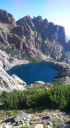
However, the hard work was far from over. The path dipped and climbed for several more hours, circling a valley containing two beautiful lakes. A particularly tricky descent down a crack in the rock was helped by a fixed chain, making it feel more like climbing than trekking! After another short ascent, Refuge de Petra Piana appeared very suddenly over the ridge - much closer than we were expecting! We were clearly getting the hang of this trek, because we reached the refuge after just 7 hours, at 2pm!
28th July Due to the time constraints of having to catch a train from Vizzavona relatively early the next day, the decision was made to combine the final two days into one. This could be done by going around the final mountain section instead of over, but it meant a long day of walking a considerable distance.
A steep descent slowly levelled out into a pleasant walk following a river downstream. Shortly before lunch we came across a footbridge over a series of pools in the river. After a quick dip to cool off, we rejoined the path. At this point we diverted away from the familiar red and white flags to follow the link road to Vizzavona. The flags had been with us constantly for more than a week, so it was an emotional moment to walk away from them. We started to feel as if the trail really was coming to an end.
A dusty path led to the village of Canaglia, and then an overgrown path back upstream took us to Vizzavona. According to the guidebook there was a free campsite in Vizzavona, but it took a little hunting to find. In exchange for camping on the grass behind the Bar Restaurant de la Gare, we were expected to buy food and drink at the café. We were more than happy with this agreement, and spent the rest of the evening eating Corsican pizza and celebrating reaching the end of the trail.
29th - 31st July After a lie-in, we packed up and left Vizzavona. The village had a rather quaint station, and from there we got a train to the islands capital, Ajaccio. The capital wasnt as pretty as Calvi, but after setting up at the nearest campsite we quickly found a nice beach at which to spend the evening. Our RnR day was spent making the most of the beautiful weather - trying to even out our awful tshirt and boot tan lines! After a bit of post-trek admin, we relaxed on the beach. An early morning flight then brought us home and back to reality!
This was a truly memorable experience for all participants, and we are thankful to the Ulysses Trust for their support.
OCdt Z Ashbridge